To gain access to the event weblink, register below.
Measured Images
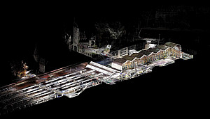
Founded in January 2018, the brilliance of SCANVISION’s work is based on many years of experience with point clouds at the Chair of Landscape Architecture Christophe Girot at ETH Zurich coupled with strong skills in conceptual, spatial and cinematic thinking. The boundaries of surveying and representation are constantly being explored and new ways of conveying spatial information are being developed. The scope of possibilities is constantly being expanded through new surveying methods, workflows and the development of sensor-based interfaces.
The work includes the surveying, documentation and visualisation of art objects, complex urban situations, large-scale landscapes, underground infrastructures and many more. With the help of surveying methods, such as 3D laser scanners, spaces are captured efficiently and in high detail. The resulting digital models are made accessible through a wide variety of representations.
The media-effective reproduction techniques range from high-resolution films to VR and AR applications to interactive programs and convey a spatial experience to the viewer. It shows the relationship of places, infrastructures, objects and spaces in a new way.
